
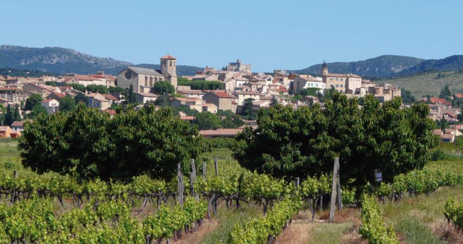
Caromb
V10 The Heritage in and around Caromb
V10
Route
Loop
Difficulty
Very easy
Duration
1h03
Distance
4km
Positive elevation gain
191 meters
Negative elevation gain
191 meters
Altitude
Min. 226 meters
Max. 390 meters
- circuit
- variante
- liaison
Departure / Arrival
/
Parking
profil altimétrique
Downloads
Traces GPX
Tourist service in Caromb :
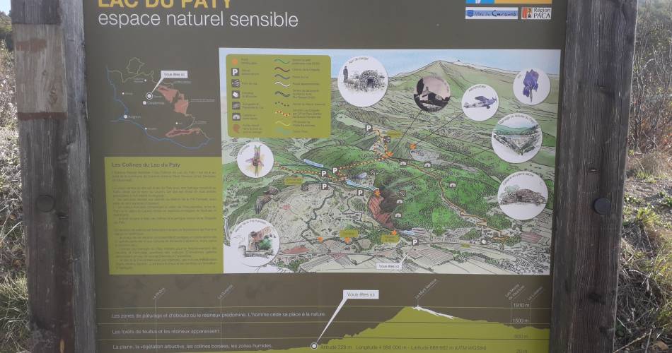
Length: 2hrs. Easy. Elevation: 160 m. Signposting: 1 dark green line. Departure: car park at the corner of the D13 and Route du Lac du Paty (signposting at the bottom of the car park, before the bridge). This circuit recounts rural life in the 19th century on the Le Paty hill.
Located in the Le Paty hills sensitive natural space (ENS – espace naturel sensible), this discovery itinerary bears witness to a past when living needed courage and persistence. This fragile forest territory was farmed until the middle of the 20th century. The dry stone heritage can be seen everywhere (private and public heritage) as a witness to this former agricultural presence: do not climb on the walls or huts, do not leave the signposted path, do not smoke. D/A (Departure/Arrival): at the angle of the D13 and the Route du Lac du Paty, there is a car park set up with an educational panel about the ENS:
Cross the car park, go to and cross the Lauron (or Brégoux), then turn left, in an olive tree grove as far as the information panel about “The Le Paty Lake hills”.
Be careful as you go, the green signposting will take you as far as the information panel located at the top of the parcel of olive trees.
Go to the route
public transportation
Nearest train station: Carpentras (fr)
TransCove bus
- From Carpentras: line L towards Bedoin / stop Camping
TransCove bus
- From Carpentras: line L towards Bedoin / stop Camping
To note
 If you want to report a problem on your hike (marking, maintenance, danger...), let us know on Suricate: sentinels.sportsdenature.fr
Access to the massifs
Respect the regulations preserving protected natural areas – find out about restrictions to accessing the massifs during fire risk periods, from 15 June to 15 September.
Before heading out, check the website
Respect the regulations preserving protected natural areas – find out about restrictions to accessing the massifs during fire risk periods, from 15 June to 15 September.
Before heading out, check the website
In brief
Contact
Ventoux Provence TourismeTel : View number 04 90 62 36 21
E-Mail : caromb@ventouxprovence.fr
Guided hikes
This page was produced with the help of theOffice de tourisme Ventoux Provence Tourisme