Sault
Cycling: Ascent of Mont-Ventoux from Sault
Tourist service in Sault :
With its legendary summit, feared by the riders of the Tour de France, Mont Ventoux is definitely worth a visit! With an average slope of 5%, the ascent of Mont Ventoux from Sault (25.6 km) is the least difficult (1,210m of elevation). Available from mid-April to mid-November.
The route can be split into 3 parts:
- From Sault to the Ventouret Chapel (12km):
The first part, 12 kilometres long, is characterised by a constant climb exposed to both winds and heat. At the third kilometre comes of the most complicated passages, with a 6% average slope, which is followed by a short respite. At kilometre 8 comes the passage known as "Ventouret”, where the slope increases as we reach an altitude of 1000m. At this point we enter the shady part of the ascent.
- To Chalet Reynard (7km):
The next 7 kilometres comprise some easier slopes and few turns. Our speed increases and all our senses are stimulated. At 1,300 metres above sea level, the road offers quiet passages with a 3% average slope. The last two kilometres offer beautiful views of the valley, numerous rest areas and a 1.5% slope, a slight flat. Then, we arrive at the Chalet Reynard, the meeting point of the Sault and Bédoin routes.
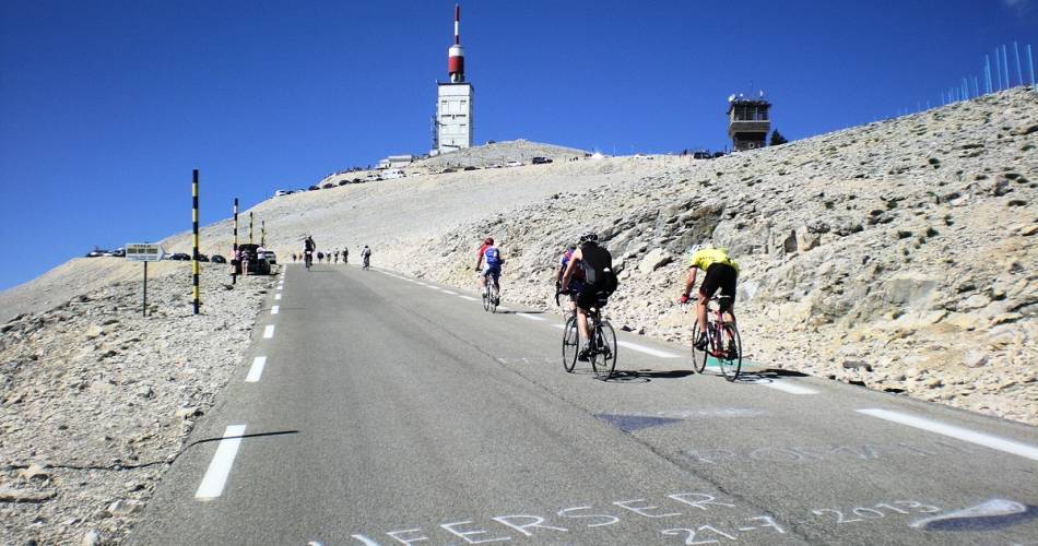
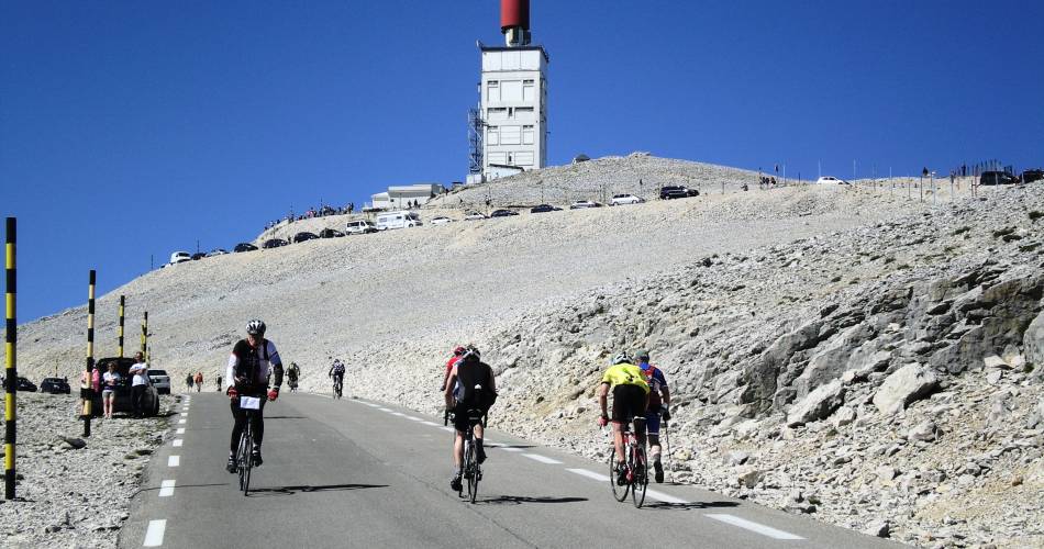
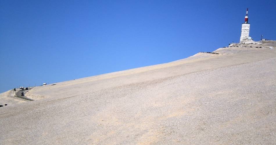
- From Chalet Reynard to the summit (6.6 km):
This last stage is the toughest as the top of the mountain is just out of our reach, just a few more pedals away. We reach the summit of Mont Ventoux for the last 6 kilometres, which have an 8% average slope. The difficulty gradually increases until the finish line at an altitude of 1,912m (11 and 12% passages.)
Practical information:
Scaling the Giant of Provence by bike requires preparation. Before your departure, train, make sure you are in peak physical condition, equip yourself with a suitable road bike, and check the weather forecast.
Most accidents occur during the descent, so be careful, take breaks and control your speed.
Avoid leaving at the hottest hours, early-morning or late-afternoon departure is recommended.
Water points on the route:
- Fountain in front of the Bédoin Tourist Office
- Fountain at Chalet Reynard
- Fontaine de la Grave (1.6km after Chalet Reynard)
Picnic areas and garbage cans are located throughout the route, please dispose of your waste properly.
Family bike ride for discovering the the fauna of Ventoux about 3km before the Chalet Reynard: starting point marked by a deer made from recycled metals. Distance: 2km. Duration: about 45minutes.
- From Sault to the Ventouret Chapel (12km):
The first part, 12 kilometres long, is characterised by a constant climb exposed to both winds and heat. At the third kilometre comes of the most complicated passages, with a 6% average slope, which is followed by a short respite. At kilometre 8 comes the passage known as "Ventouret”, where the slope increases as we reach an altitude of 1000m. At this point we enter the shady part of the ascent.
- To Chalet Reynard (7km):
The next 7 kilometres comprise some easier slopes and few turns. Our speed increases and all our senses are stimulated. At 1,300 metres above sea level, the road offers quiet passages with a 3% average slope. The last two kilometres offer beautiful views of the valley, numerous rest areas and a 1.5% slope, a slight flat. Then, we arrive at the Chalet Reynard, the meeting point of the Sault and Bédoin routes.
- From Chalet Reynard to the summit (6.6 km):
This last stage is the toughest as the top of the mountain is just out of our reach, just a few more pedals away. We reach the summit of Mont Ventoux for the last 6 kilometres, which have an 8% average slope. The difficulty gradually increases until the finish line at an altitude of 1,912m (11 and 12% passages.)
Practical information:
Scaling the Giant of Provence by bike requires preparation. Before your departure, train, make sure you are in peak physical condition, equip yourself with a suitable road bike, and check the weather forecast.
Most accidents occur during the descent, so be careful, take breaks and control your speed.
Avoid leaving at the hottest hours, early-morning or late-afternoon departure is recommended.
Water points on the route:
- Fountain in front of the Bédoin Tourist Office
- Fountain at Chalet Reynard
- Fontaine de la Grave (1.6km after Chalet Reynard)
Picnic areas and garbage cans are located throughout the route, please dispose of your waste properly.
Family bike ride for discovering the the fauna of Ventoux about 3km before the Chalet Reynard: starting point marked by a deer made from recycled metals. Distance: 2km. Duration: about 45minutes.

Dates and times
From 15/04 to 15/11 daily.
Subject to favorable weather.
Duration: 0 h
Languages spoken
- French
Prices
Free access.
Contact
Cycling: Ascent of Mont-Ventoux from SaultAvenue de la Promenade
84390 Sault
Tel :
View number
04 90 64 01 21
Facebook : https://www.facebook.com/OTI-Ventoux-Sud-1387460531503903/
Facebook : https://www.facebook.com/OTI-Ventoux-Sud-1387460531503903/
Coordinates
Longitude : 5.408266Latitude : 44.092982
> Getting there by public transport
Nearby
This page was produced with the help of theOffice de Tourisme Intercommunal Ventoux Sud