
Valréas
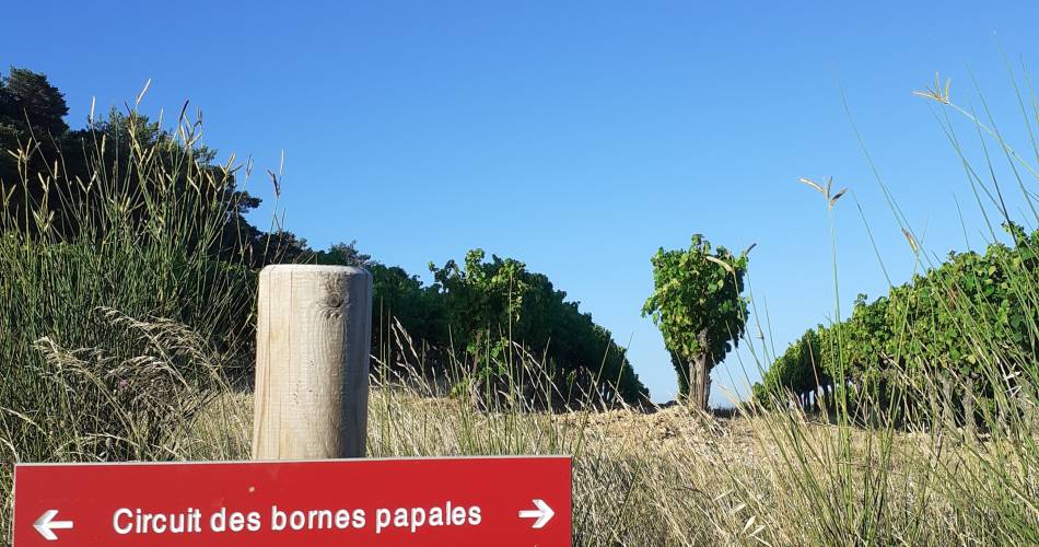
R03 Papal Milestone Path
R03
Route
Loop
Difficulty
Intermediate
Duration
3h
Distance
9km
Positive elevation gain
240 meters
Negative elevation gain
239 meters
Altitude
Min. 297 meters
Max. 478 meters
- circuit
- variante
- liaison
Departure / Arrival
Car park, Saint Pierre road / Car park, Saint Pierre road
Parking
Car park, Saint Pierre road
profil altimétrique
Downloads
Traces GPX
Tourist service in Valréas :
A walk combining countryside and historic heritage. Interpretation panels.
In the north of Provence, the villages today comprising the Enclave des Papes share a rich and complex history and geography with the communes of Bas-Dauphiné.
The coming of the Popes to Avignon in the early 14th century made these lands politically and economically important. These new overlords greedily bought up the land all around, seeking to expand the Comtat Venaissin to the north, into the lands of the Dauphiné. Their acquisitions remodelled the region’s geopolitics; the papal boundaries were the most direct expression of the expansion of the Popes’ influence.
The new owners took care to demarcate their newly acquired lands with precise boundary markers on the borders of their properties. Thus, a number of papal enclaves sprang up in the Dauphiné.
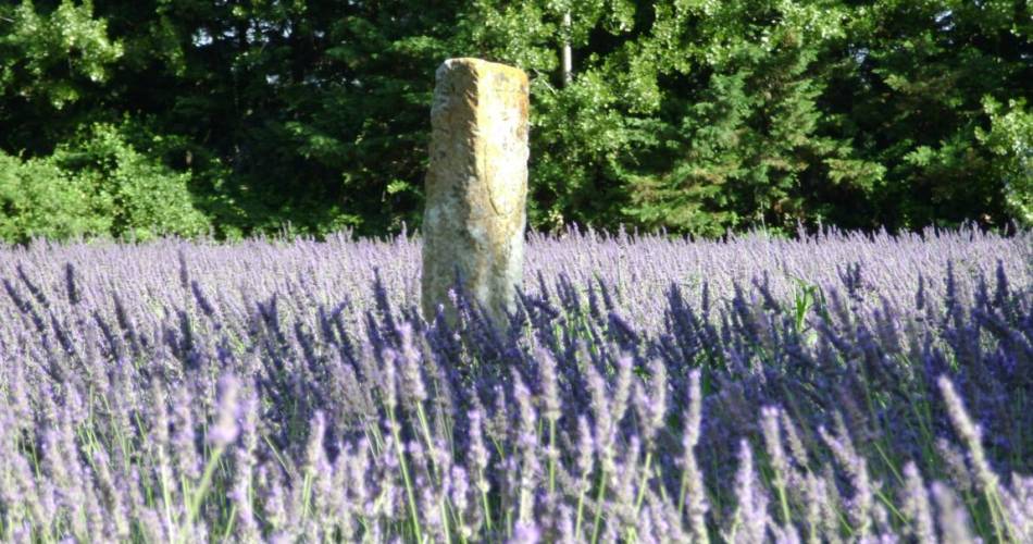
A series of boundary-marking campaigns were carried out following these acquisitions, the remnants of three of which can still be seen today: 1324, 1414 and 1457. Twenty-four boundary markers lie on the present-day limits of the canton of Valréas / Enclave des Papes.
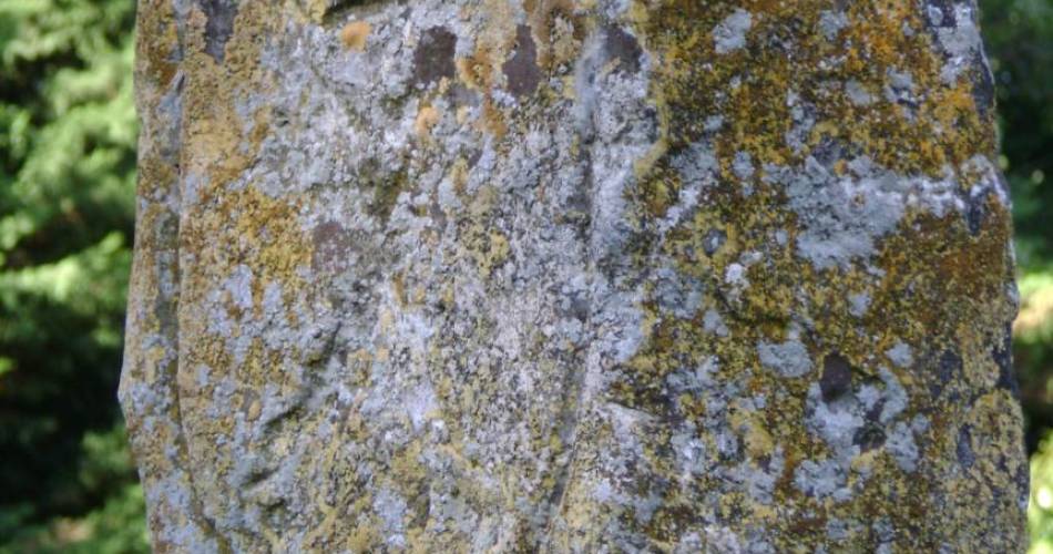
They are stone slabs 30 cm thick, 40 cm wide and 150 cm tall, carved with one or more coats of arms representing the identities of the feudal lords whose lands they are demarcating. Some are marked with one or two lines on top to show the direction of the territorial limits. The arms of the Comtat Venaissin, belonging to the pope, were two crossed keys; those of the Dauphins showed a dolphin. Occasionally, a third coat of arms specifies the identity of a particular feudal lord of the Dauphiné. Thus, on a marker near Bollène, we see the cross of the Bishop of Viviers. These papal boundary markers in our present-day landscape are an irrefutable reminder of our history. To discover them is to walk ancestral paths, offering much food for thought and serving as a pretext to explore the region. The papal boundary markers are currently being systematically catalogued.
The coming of the Popes to Avignon in the early 14th century made these lands politically and economically important. These new overlords greedily bought up the land all around, seeking to expand the Comtat Venaissin to the north, into the lands of the Dauphiné. Their acquisitions remodelled the region’s geopolitics; the papal boundaries were the most direct expression of the expansion of the Popes’ influence.
The new owners took care to demarcate their newly acquired lands with precise boundary markers on the borders of their properties. Thus, a number of papal enclaves sprang up in the Dauphiné.
A series of boundary-marking campaigns were carried out following these acquisitions, the remnants of three of which can still be seen today: 1324, 1414 and 1457. Twenty-four boundary markers lie on the present-day limits of the canton of Valréas / Enclave des Papes.
They are stone slabs 30 cm thick, 40 cm wide and 150 cm tall, carved with one or more coats of arms representing the identities of the feudal lords whose lands they are demarcating. Some are marked with one or two lines on top to show the direction of the territorial limits. The arms of the Comtat Venaissin, belonging to the pope, were two crossed keys; those of the Dauphins showed a dolphin. Occasionally, a third coat of arms specifies the identity of a particular feudal lord of the Dauphiné. Thus, on a marker near Bollène, we see the cross of the Bishop of Viviers. These papal boundary markers in our present-day landscape are an irrefutable reminder of our history. To discover them is to walk ancestral paths, offering much food for thought and serving as a pretext to explore the region. The papal boundary markers are currently being systematically catalogued.
Go to the route
public transportation
recommended parking
Car park, Saint Pierre road
road access
From the Route d'Orange (D976), head towards Valréas, then take the Chemin des Estimeurs, then turn right onto Route Saint-Pierre.
To note
Choose to do this hike in autumn to enjoy the wonderful colours.
 If you want to report a problem on your hike (marking, maintenance, danger...), let us know on Suricate: sentinels.sportsdenature.fr
Access to the massifs
Respect the regulations preserving protected natural areas – find out about restrictions to accessing the massifs during fire risk periods, from 15 June to 15 September.
Before heading out, check the website
Respect the regulations preserving protected natural areas – find out about restrictions to accessing the massifs during fire risk periods, from 15 June to 15 September.
Before heading out, check the website
In brief
- This is a circuit dotted with panels that enable you to learn more about the history of the Enclave des Papes and their “papal boundary markers”.
- Landscapes alternating between oaks and vineyards.
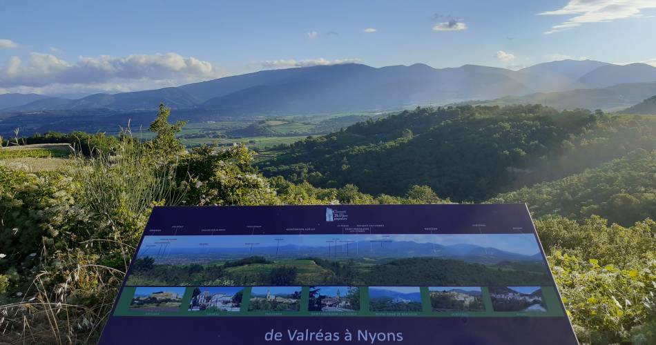
- Wonderful views of the Lance mountain, Mont Ventoux, Vinsobres.
Downloads
Contact
Office de Tourisme Pays de Grignan - Enclave des PapesTel : View number 04 90 35 04 71
E-Mail : info@grignanvalreas-tourisme.com
Guided hikes
This page was produced with the help of theOffice de Tourisme Communautaire Pays de Grignan et Enclave des Papes